EAST TENNESSEE GEOLOGICAL SOCIETY
November 2020 Virtual Meeting
Monday,
November 9, 2020
6:00 - 7:30 pm
Note: ETGS members will receive an email with info for logging into the meeting.
NOVEMBER PRESENTATION
Progress Toward A Preliminary Karst Depression Density Map for the Conterminous
United States: Tennessee Update
More info!
By
Daniel H. Doctor
U.S. Geological Survey, Florence Bascom Geoscience Center, 12201 Sunrise Valley
Drive, MS926A, Reston, Virginia, 20192 USA, dhdoctor@usgs.gov
Abstract
Most methods for the assessment of sinkhole hazard susceptibility are predicated upon knowledge of pre-existing closed depressions in karst areas. In the United States (U.S.), inventories of existing karst depressions are piecemeal, and are often obtained through inconsistent methodologies applied at the state or county level and at various scales. Here, we present a first attempt at defining a karst closed depression inventory across the conterminous U.S. using a common methodology. Automated algorithms for extraction of closed depressions from 1/3 arc-second (approximately 10 m resolution) National Elevation Dataset (NED) were run on the U.S. Geological Survey (USGS) "Yeti" high-performance computing cluster. The full NED was first conditioned to reduce the creation of artificial closed depressions by breaching digital dams at road and stream crossings, using the flowlines and transportation route vectors from the USGS National Map. The resulting depressions were selected according to location within geologic units having the potential for karst, and screened for occurrence in areas of developed land, open water and wetlands, and areas of glacial and alluvial sediment cover. The results were used as the input to create a nationwide depression density map. Our results were compared with karst depression density maps for diverse karst regions within states that have existing closed depression inventories. The individual state-scale maps compared favorably to the results obtained from the method applied universally across the nation and illustrated regional sinkhole hotspots in known areas of well-developed karst. Limitations of the automated method includes false positive depressions resulting from artifacts generated during the computer processing of the elevation models, and inclusion of depressions resulting from non-karst geomorphic processes. More thorough examination of the screening criteria for depressions is required.
Biography
Dan Doctor is a research geologist with the U.S. Geological Survey specializing in the study of karst regions. Dan holds a B.A. in Geology from Colgate University and a Ph.D. in Hydrogeology from the University of Minnesota with a doctoral minor in Water Resources. He was awarded a Fulbright scholarship in 1998 to study the hydrogeology of the Classical Karst of southwestern Slovenia for his doctoral dissertation. In 2002, Dan joined the US Geological Survey as a National Research Council postdoctoral associate. His research interests include the hydrology and geochemistry of karst aquifers, the assessment of sinkhole hazards, the evolution of karst landscapes, and the generation of paleoclimate records from karst areas. Dan is a fellow of the Cave Research Foundation, has served the board of the Karst Waters Institute (KWI), and was appointed by the Governor of Virginia to the Virginia Cave Board, which he currently chairs.
|
SHORT COURSE FOR IDENTIFICATION OF SINKHOLES FROM LIDAR IMAGERY |
||||||||||||
|
|
|
|||||||||||
|
||||||||||||
|
||||||||||||
|
Additional links and information are provided below.
|
||||||||||||
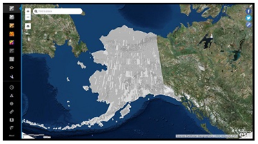
USGS 3D Elevation Program Lidar viewer:
https://apps.nationalmap.gov/3depdem/
|
|
This web application enables the investigation into a collection of Arctic DEMs. These are primarily created by the Polar Geospatial Center covering the majority of the Arctic.These services are temporal and the app provides tools to review how Arctic has changed over time. |
The National Map (for downloading lidar data):
https://viewer.nationalmap.gov/basic/
|
|
Open the product list by clicking "results" next to the product count. Users can display the footprint and thumbnail of one or more products, view metadata, directly download the file or add to a Cart. |

Sinkhole Conference Proceedings paper on Hydrocutter toolbox for ArcMap:
https://scholarcommons.usf.edu/sinkhole_2015/ProceedingswithProgram/GIS_Databases_and_Maps/5/
|
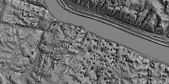
Closed depressions on the land surface can be identified by "filling" a digital elevation model (DEM) and subtracting the filled model from the original DEM. However, automated methods suffer from artificial "dams" where surface streams cross under bridges and through culverts. Removal of these false depressions from an elevation model is difficult due to the lack of bridge and culvert... |
Sinkhole Conference Proceedings paper on sinkhole density map:
https://scholarcommons.usf.edu/sinkhole_2020/ProceedingswithProgram/GIS_Mapping_and_management/1/
|
Most methods for the assessment of sinkhole hazard susceptibility are predicated upon knowledge of pre-existing closed depressions in karst areas. In the United States (U.S.), inventories of existing karst depressions are piecemeal, and are often obtained through inconsistent methodologies applied at the state or county level and at various scales. Here, we present a first attempt at defining ... |
![]()
Greetings, and welcome to the November 9, 2020 ETGS virtual meeting.
We hope you, your family, and your colleagues are staying healthy
and well as we endeavor to "flatten the curve".
As a courtesy please mute your cell phone or the microphone in your laptop/tablet to minimize background noise and feedback echos. We will also make an effort to mute all participants - at least until the presentation is finished. Please use the chat feature to type any comments or questions you may have. We recommend that you send questions for the speaker to "everyone" so all participants can see the question. In the interest of time, we may hold the Q&A at the end of the presentation.
We will create a virtual attendance list. It is not always possible
to tell who is participating, especially for those joining by phone,
so please email
etgs@etgs.us
to be listed on the attendance sheet. Let us know exactly how your
name should appear on the list. We will add a note explaining the
lack of signatures due to COVID-19-induced distancing and have an
ETGS officer sign as usual.
Thank you for your patience and understanding as we try this online
format. As always, we welcome and appreciate your feedback and
suggestions for improvement.
Page updated November 22, 2020 |